Seismic Hazard and Microzonation
Central Asia is a region prone to large earthquakes, as evident by its historical seismicity. A first update of the Soviet era seismic hazard map, which was based on the maximum expected seismic intensity in MSK-64 units, has been provided by the GSHAP project [Zhang et al., 1999]. The probabilistic seismic hazard maps at regional scale computed for Kyrgyzstan [Abdrakhmatov et al., 2003] show a peak ground acceleration of up to 4.5 m/s2 with a 10% probability to be exceeded over the next 50 years, confirming the very high seismic hazard of the region.
Within EMCA, seismic hazard assessment will be carried out by considering different approaches and parameters.
In particular, cross border seismic hazard maps in terms of intensity and parameters of engineering interests will be calculated using a site approach [Albarello and Mucciarelli, 2002; D’Amico and Albarello, 2008], a spatially smoothed seismicity approach [Frankel, 1995] and a standard Cornell approach [Cornell, 1968]
The input data will be organised following the GEM standards and calculations will be carried out taking advantage of the OpenGEM software.
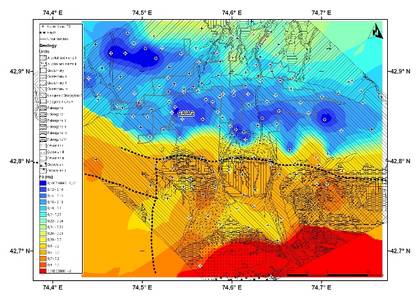
In areas of intensive urbanisation (capital and other major cities) microzonation activities will be conducted and the results considered in the seismic hazard and risk assessment.
The microzonation of Bishkek was recently carried out (Parolai et al., 2010) and those of several other towns (Tashkent, Almaty, Dushanbe) have been started.
The Institute of Geophysical Research (IGR) coordinates the task of compiling the new seismic catalog.
The Institute of Seismology (Kyrgyzstan) coordinates the task of compiling the new fault catalog